

Town receives Historic 1917 Sanborn Map
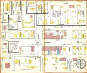 The New Franklin, Missouri Board of Alderman were recently presented with a 1917 Sanborn Insurance Map of the city. The Boonville Daily News reports that the map was donated to the city by Councilman Walter Banks. The map has been scanned and a copy is available on CD, while the original will be archived. Interestly, the News reports that the compass rose on the map is pointing in the wrong direction.
Beginning in 1867, the Sanborn Map Company produced maps covering approximately 12,000 cities and towns in the United States, Canada, and Mexico. They were primarily designed to assist fire insurance agents in assessing risks. They show the size, shape, and construction of dwellings, commercial buildings, and factories, as well as building details, streets, property boundaries, addresses and utility information.
Sanborn maps provide a wealth of historical information about North American cities. The Sanborn collection is comprised of approximately 7,000 individual maps. The largest collection of Sanborn maps is in the Library of Congress.
posted by Roger Hart @ 1/10/2006
|
![]()
![]()


<< Home