

Small Firm Combines GIS With Historic Maps
 Two students from the University of Southern Maine (USM) have recently gone full-time with their firm which specializes in combining Geographic Informations Systems (GIS) technology with historic maps and other records. Maine Today has a story about Rosemary Mosher and Kirsten Read Boettcher, co-founders of Orbis, LLC.
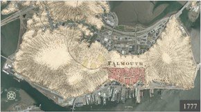
Orbis specializes in "land use investigations and historical forensics." The firm uses GIS to create layered maps that show historic geographies and ways property was used in the past.
From Maine Today:
They make innovative uses of mapping software and combine it with painstaking and extensive historical document searches to create rich and graphic portrayals of areas. The end result can tell a real estate developer, for instance, what the history of a parcel is, whether he might encounter graves from a century-gone churchyard or ground contaminated with arsenic from a tannery that was there 80 years ago.
That sort of graphic interpretation is valuable to many different types of businesses, said Meriby Sweet, director of the Maine Small Business and Technology Development Center at the Maine Technology Institute. Sweet has advised Orbis on the company's business model."It provides the linkage between the sort of dry, flat map that says, 'Here's where we sit on the surface of the earth, this is where the boundaries are, where the lakes and rivers and oceans are,' and it adds the dimension - 'look, there's this whole long history of people actually inhabiting this not-so-flat surface,' " said Sweet.
The two principals met at USM. A professor suggested they work on a project together - one that combined GIS with history. When the project ended, they worked various freelance jobs together, combining historic and modern maps using GIS. In 2004, they founded Orbis.
The firm seems to have a found a niche in the environmental field. Ms. Mosher told Maine Today she thinks Orbis can help developers recognize potential issues before they become problems through a better understanding of historical land uses.
Labels: GIS, Historic Maps
posted by Roger Hart @ 3/10/2006
|
![]()
![]()


<< Home