

Did Chinese Discover America?
 New evidence is about to come forward to support the theory that the world and its continents were discovered by a Chinese admiral named Zheng He between 1405 and 1435.
The Economist has the story:
Next week, in Beijing and London, fresh and dramatic evidence is to be revealed to bolster Zheng He's case. It is a copy, made in 1763, of a map, dated 1418, which contains notes that substantially match the descriptions in the book. ÂIt will revolutionise our thinking about 15th-century world history, says Gunnar Thompson, a student of ancient maps and early explorers.Some of the features of the map:
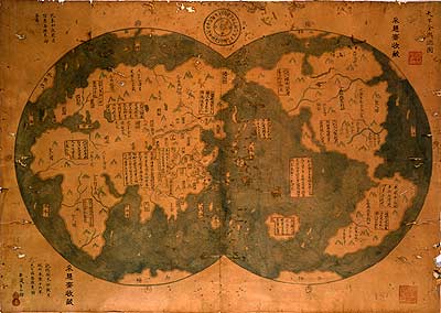
The map (shown above) will be unveiled in Beijing on January 16th and at the National Maritime Museum in Greenwich a day later. Six Chinese characters in the upper right-hand corner of the map say this is a Âgeneral chart of the integrated worldÂ. In the lower left-hand corner is a note that says the chart was drawn by Mo Yi Tong, imitating a world chart made in 1418 which showed the barbarians paying tribute to the Ming emperor, Zhu Di. The copyist distinguishes what he took from the original from what he added himself.
The detail on the copy of the map is remarkable. The outlines of Africa, Europe and the Americas are instantly recognisable. It shows the Nile with two sources. The north-west passage appears to be free of ice. But the inaccuracies, also, are glaring. California is shown as an island; the British Isles do not appear at all. The distance from the Red Sea to the Mediterranean is ten times greater than it ought to be. Australia is in the wrong place (though cartographers no longer doubt that Australia and New Zealand were discovered by Chinese seamen centuries before Captain Cook arrived on the scene).Skeptics point to the map's precision as evidence that the map is not a copy of the 1418 original but from a later time. Supporters argue that the map is consistent with what the Chinese knew about geography at the time. An interesting feature of the map are the errors, errors which later showed up on European maps. The map depicts California drawn as an island, an error that would later appear on European maps. The has led some to suggest that Europeansrporeans copied their maps from the Chinese.
The commentary on the map, which seems to have been drawn from the original, is written in clear Chinese characters which can still be easily read. Of the west coast of America, the map says: ÂThe skin of the race in this area is black-red, and feathers are wrapped around their heads and waists. Of the Australians, it reports: ÂThe skin of the aborigine is also black. All of them are naked and wearing bone articles around their waists.Â
Authentication of the map would mean that the new world was first discovered by Chinese and not European explorers would mean a major revision of world history as we know it. We might even have to rename Columbus Day to Zheng He Day.
posted by Roger Hart @ 1/12/2006
|
![]()
![]()


<< Home