

Map Of Alaskan Refuge Is Missing
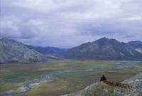 The only copy of the map of the Arctic National Wildlife Refuge is missing. The New York Times reports that when Congressional aides went to retrieve the map from storage in Arlington, Virginia, it was gone. The wall-size map, drawn at a scale of 1:250,000 feet, depicted the tundra in the environmentally sensitive area, which has been the source of a bitter debate over plans to allow oil exploration there. The map had last been seen in late 2002. There were no copies and no digitized version.
The loss of the map may have very real-world consequences. The U.S. Geological Survey prepared a new map. However, opponents to oil exploration have said that the new map includes tens of thousands of acres of coastal plains that were not included on the original map. Inclusion of those areas on the map would make it easier to drill for oil there.
The Times quotes Doug Vandegraft, the cartographer for the Fish and Wildlife Service who is the last known person to see the map as saying, "People have asked me several times, 'Do you think someone took this intentionally?' I hope to God not. So few people knew about it. I'm able to sleep at night because I don't think it was maliciously taken. I do think it was thrown out." Mr. Vandegraft said he had folded the map in half, cushioned within its foam-board backing, and put it behind the filing cabinet in a locked room for safekeeping. When the aides sought to retrieve the old map, there was only a new, folded piece of foam board, similar to the old one, but with one big difference. There was no map attached. No one has admitted knowing what happened to the map.
Complete article from The New York Times. (Registration required)
posted by Roger Hart @ 10/20/2005
|
![]()
![]()


<< Home