

Old & New Combine To Map "Eternal City"
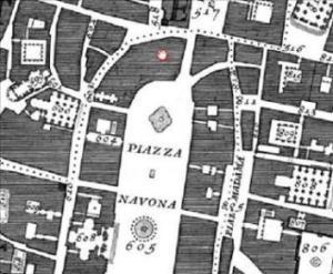 In 1748, architect and surveyor Giambattista Nolli completed a map of his hometown of Rome titled, "The Pianta Grande di Roma" (Great Plan of Rome). The map, which was made from 12 minutely detailed copper plates, measured six by seven feet. It was so accurate that it continued to be used as the basis for government maps of the city until the 1970s.
Nolli's map featured several cartographic firsts including:
- The first map to use the ichnographic, or plan, style rather than the more popular "bird's eye view."
- The first map to use dark shades to mark buildings and private spaces and light shades for streets and public spaces.
- The first map oriented so that North, rather than East, was at the top of the page.
The University of Oregon's site will be of interest to both ancient map enthusiasts as well as anyone in the survyeing, mapping and GIS professions. One of the innovations of the site is that it combines Nolli's ancient map with a layer containing a 1-meter resolution satellite image of the city from Space Imaging, Inc. By combining this new and old technology, the site allows the viewer to compare "before" and "after" views of the city, revealing how little the "Eternal City" has changed in two centuries. Comparing modern satellite image with Nolli's hand drawn map, one can only marvel at the extraordinary accuracy of his map, leaving the viewer to wonder if cartographers 250 years from now will have similar admiration for their current work.
The Interactive Nolli Map Website.
Complete article from the Christian Science Monitor.
posted by Roger Hart @ 10/18/2005
|
![]()
![]()


<< Home