GeoCarta Has Moved

Sep 30, 2005

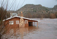
4H Youth Learn Mapping Skills

Young people in four North Dakota 4-H clubs are learning mapping skills and helping their communities using the latest Geographic Information Systems (GIS) and Global Positioning Systems (GPS) technology. The four 4-H groups received grants from California software maker Environmental Systems Research Institute this year. The 4-H clubs are using GIS and GPS to learn how geospatial technologies are used in agriculture and other industries. In addition to commercial uses, participants are also using GPS to identify and mark tourism points of interest, including historical points, unique local businesses, day-trip sites, walking and biking trails and birding sites. Others are locating and marking all of the rural cemeteries in the county and cooperating with community officials to list the names and information of individuals interred at these sites. They use the GIS programs to display the data collected in their projects and to make the information available for interested community members. Hopefully, programs like this will grow and encourage young people to consider a career in surveying/mapping.

Complete article from Farm & Ranch Guide.

Sep 27, 2005

City Council Orders Contentious Map Redrawn

After a long contentious meeting pitting outdoor enthusiasts against property rights advocates, the Billings, Montana City Council has ordered the Heritage Trail Plan redrawn. The map was intended as a strategy for implementing the city's vision of increasing non-motorized transportation over the next 10 to 20 years, as well as a guide for future trail and bikeway development. Trail advocates said that the comprehensive trail plan was essential to developing safe, nonmotorized transportation inside and outside the city. Rural property objected to the map's depiction of proposed trails across private property. Property which the owner had not granted permission for the trail to cross. Property owners argued that the plan was a threat to their private property rights.


After a two hour hearing, the City Council ordered the plan redrawn to eliminate proposed trails extending across private property. Instead, maps included in the plan will feature only conceptual sketches of areas that could be considered for future trail development. Potential starting and ending points for proposed trails will be shown, but no lines crossing private property. The maps will also feature a prominent disclaimer that says that property owners haven't given up any rights even though trails are being considered in their neighborhood.

Complete article from Billings Gazette.


Sep 25, 2005

Mapping A Final Resting Place

A sixty year-old map of Iwo Jima,

carried home as a battlefield souvenir may hold the key to locating the remains of one of the most famous photographers in United States history. The map, which shows caves and enemy positions, was taken home by Michael P. Carrera, a veteran of the battle, as a war souvenir. Marine veteran Bob Bolus hopes to use the map along with modern day Global Position System devices, to locate the site of the cave where Sgt. Bill Genaust died.

Sgt. Genaust is the man that took the famous picture of U.S. Marines raising the American flag on Iwo Jima’s Mount Suribachi. Nine days later, Sgt. Genaust was shot to death as he and other Marines checked Cave 362A for enemy troops. Sgt. Genaust never saw the results of his work and never knew how famous the shot would become. One of the bloodiest battles in Marine Corps history, Iwo Jima continues to hold a unique fascination for Marines. Every year, veterans of that fierce battle return to remember what happened there, and those who died.

Complete article from Scranton Times-Tribune.

Sep 22, 2005

Fake Maps Leave Chinese On Wrong Road

Driving through Shanghai can be a challenge, what with the constant traffic jams and roads that seem to be eternally under construction. To help navigate the busy streets of China's largest city, many drivers have embraced GPS navigation systems. The systems rely on satellites to determine a vehicle's location. Using electronic maps, they then can show a driver which route to take. Unfortunately instead of helping plot the shortest course between two points, some of the devices are getting people lost. The reason? Some of them are based on counterfeit electronic maps. The Shanghai Daily reports that the Chinese Academy of Surveying and Mapping granted eight companies certificates allowing them to produce electronic navigation maps. In order to save money, some of the producers of the GPS devices used counterfeit maps instead of the official ones. It is believed that there are now more fake maps than legal ones.

Complete article from BBC News.

Sep 21, 2005

Plans Gone Awry

Planning officials with Montgomery County, Maryland are trying to determine how numerous homes were allowed to be built in Clarksburg Town Center on lots that failed to meet the 4,000 square feet minimum required by site plans. According to The Washington Times, some plat maps do not match the site plans that they are supposed to be drawn from. In some instances the type and number of homes shown on the plats differ from what is shown on the site plans. No one knows exactly how many homes have been built on lots that failed to meet the county's minimum size. A resident's group which first discovered the errors estimates the number at two dozen.

During the summer, the county Planning Board discovered that more than 500 homes in Clarksburg were built too high or too close to the street. In one instance, a planned pedestrian walkway that was supposed to connect a 217-year-old church to the town center was eliminated, leaving the church cut off from the development by a large shrub covered berm. The Planning board says that a former staffer altered a site plan to cover up the violations. County and state officials are investigating the mess.

Sep 20, 2005

U.S. Agencies Team Up To Map Damage To Barrier Islands

USGS, NASA and the U.S. Army Corps of Engineers have teamed up to utilize airborne laser mapping systems to chart changes to the gulf coast brought about by Hurricane Katrina. Elevation data from before and after the hurricane are compared to determine the patterns and magnitudes of coastal change. Such changes include erosion and destruction of buildings and other structures. Three lidar surveys were collected using two different systems to map the devastation.

One area where the impact of the hurricane is most clearly visible is on Dauphin Island, a barrier island located about 90 miles from where the eye of the storm hit land. The storm surge covered the island and waves transported sand landward, leaving fan-shaped deposits. The entire island was moved landward, destroying numerous houses. NASA has created an animation of the storm's effect on Dauphin Island that can be seen at: http://www.nasa.gov/vision/earth/lookingatearth/katrina_poststorm.html.

Sep 19, 2005

Dueling Maps To Settle Fate Of Endangered Species

Petaluma California officials plan to prepare their own map depicting the habitat of the California Tiger Salamander after one prepared by the U.S. Fish and Wildlife Service included prime development areas of their city. Federal officials have proposed that almost 74,000 acres of the county be designated as,"critical habitat" for the endangered amphibian, including parts of Petaluma. The Fish and Wildlife Service is under court order to designate "critical habitat" for the salamander by Dec. 1. However, the Service admits that they deliberately included areas of the species' "historical range" where salamanders have never been spotted. The federal agency is counting on public comments to help them redraw the map to more accurately reflect the true habitat of the salamander.


The city is conducting its own environmental studies to show that the U.S. Fish and Wildlife Service's map incorrectly includes part of Petaluma. City officials contend that the tiger salamander has never lived in their area. If the Fed's map stands, it could prohibit development in some prime areas of the city, costing thousands in lost tax revenue. The city plans to have their own study completed by October 3.

Complete article from Petaluma Argus Courier.

Sep 17, 2005

The Map That Changed The World

Buffalo's Central Library has put on display its copy of William Smith's 1815 geological map of Great Britain. The rare map, one of only 40 hand-made copies that remain, was the first geological map of any country in the world. It has been called, "the map that changed the world" because its mapping of the earth's layers and fossils, is said to have influenced the work of Charles Darwin and the world's coal and oil industries. Smith, who eventually became known as the, "Father of English Geology" noticed layers in the rocks and that the fossils varied from layer to layer in the canals he was digging. His studies formed the foundation for a new chronology of the earth's history and provided a tool for detecting coal and oil reserves. Unforntunately, the Father of English Geology wound up in debtor's prison and was even homeless for a while. Years later the importance of his work was recognized and was recently the subject of a best selling book, by Simon Winchester.

Newsday reports that the exhibit, put together with the help of University at Buffalo scientists, has geologists from all over the country making plans to travel to Buffalo to view this map. The only other copy in the United States lies in the Library of Congress. The exhibit runs through the end of the year.

Sep 15, 2005

Mapping The Devastation

There is an excellent article today from the Colorado Springs Gazette on the efforts of the Spectral Operations Resource Center of the U.S. Army Space and Missile Defense Command to continuously map the receding flood waters in New Orleans and the environmental dangers left behind by Hurricane Katrina. The group works through the night, using data from imaging satellites to produce maps and images to guide rescuers for the next day's operations. Among their tasks are determining floodwater elevations to identify which roads are passable, and identifying safe landing zones for helicopters. They also map out gas stations, petroleum plants and other environmentally hazardous locations.

The map at left is from the Gazette and is an example of the maps being produced. The different colors indicate water depths.

Sep 13, 2005

Straightening Out A Crooked Map

There's an excellent article today from the Bradenton Herald on how closing errors made over a hundred years ago in the U.S. Public Land System continues to affect land use and development today.

Under the system, which was first proposed by Thomas Jefferson, surveyors established true north-south and east-west base lines. From these axesis, surveyors set lines every 24 miles in each direction that were slightly adjusted to account for the Earth's curvature. The resulting boxes then were subdivided into 16 smaller ones, called townships, that measured six miles on each side. Townships were further subdivided into 36 one-square-mile blocks, called sections. These sections formed the basis for private land ownership through most of the United States. The results of this system can still be seen in checkerboard look across much of rural United States.


While the system looked great in theory, the on-the-ground application was left than perfect. Rudimentary equipment and harsh conditions combined to make many of the sections far from square. In many cases, these errors leave property lines and street intersections offset, in some cases by large distances. As streets are widened and improved for heavier traffic loads and faster speeds, governments find themselves spending large sums to straighten out these offset lines,

An excellent source for information on the U.S. Public Land System is the book, Measuring America, by Andro Linklater.


Sep 11, 2005

Officials in Calif. Seek Flood Map Revision

While some areas of the country deal with new, more accurate flood maps placing more land in the flood plain, officials in California are trying to get an area around San Marcos Lake removed from the flood plain.

Officials are spending $40,000 to for a study to revise the Flood Insurance Rate Maps that would remove much of the land around Lake San Marcos from the flood plain. Federal law requires that lenders require homeowners living within a flood zone to buy insurance if they have a mortgage or refinance their home. Removing the homes from the flood zone would remove this requirement, saving property owners hundreds of dollars a year in flood insurance premiums.

Complete article from North County Times.

Sep 9, 2005

Inaccurate Map Costs $15,000

Rock and gravel: $200
Concrete footings: $1,000

Building a bridge on someone else's property: $15,000
There are some things money can't buy, but before you spend $7 million on a new bridge you might want to make sure your maps are accurate.

N
o, that's not the latest MasterCard commercial, that's what the City of Gearhart, Oregon is having to pay Marie Smith and Ilona Johnson after mistakenly pouring concrete footings for a new bridge on their property. OregonLive.com reports that the City Manager informed the Gearhart City Council that the city poured the concrete footings for the bridge based on an inaccurate map. This resulted in the footings being located on private property. The city is paying the landowners $15,000 as compensation. The footings are part of a $7 million project.

Sep 8, 2005

Sinking In New Orleans

Prior to Hurricane Katrina's landfall, I mentioned a study by the National Oceanic and Atmospheric Administration that suggested that elevations along the gulf coast were not as shown on current maps due to subsidence. Wednesday's Wall Street Journal reports that subsidence may in fact, have played a role in the devastating flooding of New Orleans caused by Katrina. According the U.S. Army Corps of Engineers, the levees along the Industrial Canal are supposed to be 15 feet above sea level. However, The Journal has found a Project Fact Sheet on the New Orleans District's web site which states, "...several levees have settled and need to be raised to provide the design protection. The current funding shortfalls in fiscal year 2005 and fiscal year 2006 will prevent the Corps from addressing these pressing needs."

Most cartography assumes that the earth remains stable. Subsidence throws that assumption out and renders maps obsolete. A possible scenario may have gone as follows. Back in the 1960's the Corps determined that to protect the city from a Category 3 hurricane, the levees needed to be 15 feet above sea levee. However, over the years, the land has subsided, leaving the tops of the levees at perhaps 14 feet above sea level. Which would mean the city did not have the protection they believed they did. In all the talk of rebuilding New Orleans, the first order of business should be a new mapping project to determine the true elevations of the city.

Of interest: New Orleans area hurricane levee maps from New Orleans District, U.S. Army Corps of Engineers.


Sep 7, 2005

Update On Katrina

Echoing a question I asked the other day, Forbes Magazine has an story on the outdated flood maps for New Orleans. The article states, "...many home owners may have wound up in harm's way because outdated government maps didn't indicate they were in a flood zone." As I showed in my previous post, people living in New Orleans proper would definitely have known they were in a flood zone. However, the magazine raises the valid issue of people living in suburban areas. FEMA is incredibly slow about updating their flood maps to reflect new development. According to the magazine, about 75% of the nation's flood maps are outdated. FEMA's flood map modernization is supposed to be completed by 2010. However, the project is behind schedule.

While improving safety, more modern maps may likely make rebuilding along the gulf more expensive. Often where they are updated, the flood maps have higher flood elevations. This means the building elevation must be elevated, resulting in greater construction costs.

Edited to add: I see that Cartography came upon the Forbes article before I did. You might want to check it out.

Not wanting to spend my time duplicating the good work of others, I have not even tried to compile a list of online maps of Katrina's damage. The Map Room is a excellent resource for that. Another good resource is Cartography.

Lastly, station WCCO has a story about two guys from Austin, Texas that have created an online map which allows the victims of the hurricane to share information. Though I read the story twice, I could never find the web address.

Edited 09.08.05: The link to the map mentioned above is: http://www.scipionus.com/ Thanks to Larry Eamigh for pointing it out to me.

Sep 5, 2005

New Orleans Flood Map

In a previous post I mentioned the Flood Insurance Rate Maps prepared by the Federal Emergency Management Agency (FEMA). So the question arose, "what do the flood maps show for New Orleans?" So I got on FEMA's website and made a map of a portion of the city. The title block is at the upper right.

In the lower right, is a small section of the flood map. The shaded areas indicate land that lies in the 100 Year Flood Plain. Considering the news reports, it comes as no surprise that nearly the entire city is located in the flood plain. The two white fingers you see at the bottom of the map are the tops of levees. I hope it is legible, but below the label, "Zone A0" is the the statement, "Depth 1.5" This would indicate that the flood waters would reach a depth of 1.5 feet. While I am no hydrologist, it is clear that this flood map only contemplates the flooding that will occur from rain fall. When a 100 year rain comes, the water will naturally flow towards the river, lake and canals. The levees around these bodies of waters block this storm water and cause localized flooding. However, the flood maps clearly do not contemplate the castastrophic failure of the levees. This is true of any area of the country protected by levees, the flood study assumes the flood structures will function as designed. However, I can't help but wonder if these maps did not contribute to a false sense of security among New Orleans' residents and government officials. 1.5 feet of flood water does not pose nearly as great a potential for lose of life as 20 feet. Perhaps FEMA should take a look at this issue and consider modifying their maps in areas protected by man-made structures.

I posted a full-size version of the flood map here. Be warned, its 5.1 mb in size.

Sep 2, 2005

NOAA Begins Surveying Damage to Mississippi River


Today's Wall Street Journal reports that the National Oceanic and Atmospheric Administration (NOAA) has begun mapping the damage done to the Mississippi River shipping channel by Hurricane Katrina.

The picture at the top is the shipping channel and delta prior to Katrina. Land appears green in the satellite image. The lower image shows the same area. The lack of green illustrates the large area that is currently underwater. The submersion of this area increases erosion of Louisiana's coastline. It is feared that the Mississippi may even someday change course. Louisiana has lost more that 1,900 square miles to erosion in the last 75 years.

NOAA has deployed researchers to the ship channel to use sonar to survey the channel for potential underwater obstructions and damage. It is possible Katrina may have left cars, boats or even houses on the bottom of the channel. Whether large ocean-going ships can safely navigate the channel or not will not be known for at least several days.

Complete article from The Wall Street Journal (Subscription required)


Sep 1, 2005

New Technology Puts Old Irish Maps To Use

Back in 1837, Ordnance Survey Ireland (OSI) began mapping the country, ultimately producing handrawn maps of the entire country. These maps, drawn at a scale of 6 inches to a mile, were etched in reverse on copper plate, printed in gray scale and then hand colored. Now after three years of work, ESRI Ireland, a geographical information systems firm working for the OSI has taken these historic maps and joined them together seamlessly. The ultimate goal is to make them available online.

The project will allow users to simply enter the name of a county and townland and be shown layers of historic maps of the area. Initially, the maps will be available at libraries in Ireland. A world-wide launch is planned for 2006.

Complete Article from Silicon Republic.


When Nature Revises Maps

A Maryland lawsuit provides a timely reminder that what is depicted on a map or deed and the reality on the ground may be two different things. Laurese Katen and Larry Pusey are suing Mark and Doris Good contending that the Good's fence blocks access to their property. What makes this unusual is the property the Katen's are demanding access to lies under the Annemessex River. While we might question the wisdom of someone who purchased underwater lots, the issue is not unimportant since the property could become valuable riverfront property if filled in. However, the greater issue is the theory of navigable waters. When this country was settled, the rivers and streams that traverse it were avenues of commerce. Generally speaking, the government kept title to most of the rivers and streams and continues to hold title to this day. Not only does the government retain title to rivers but as those rivers erode more land away from their banks the government's property actually moves with it. Such is the contention in the Maryland case where the defendants are contending that title to the underwater lots actually belongs to the State of Maryland.

Similar principles apply to land bounded by the oceans and the gulf. As the tides wash away the earth, they are literally washing away people's land. When they are able to return, the residents of gulf front property may find that not only have their homes and businesses been severely damaged, but they may find that the size of their land has been diminished as well.