

Sinking In New Orleans
 Prior to Hurricane Katrina's landfall, I mentioned a study by the National Oceanic and Atmospheric Administration that suggested that elevations along the gulf coast were not as shown on current maps due to subsidence. Wednesday's Wall Street Journal reports that subsidence may in fact, have played a role in the devastating flooding of New Orleans caused by Katrina. According the U.S. Army Corps of Engineers, the levees along the Industrial Canal are supposed to be 15 feet above sea level. However, The Journal has found a Project Fact Sheet on the New Orleans District's web site which states, "...several levees have settled and need to be raised to provide the design protection. The current funding shortfalls in fiscal year 2005 and fiscal year 2006 will prevent the Corps from addressing these pressing needs."
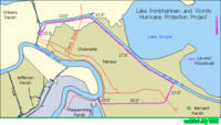
Most cartography assumes that the earth remains stable. Subsidence throws that assumption out and renders maps obsolete. A possible scenario may have gone as follows. Back in the 1960's the Corps determined that to protect the city from a Category 3 hurricane, the levees needed to be 15 feet above sea levee. However, over the years, the land has subsided, leaving the tops of the levees at perhaps 14 feet above sea level. Which would mean the city did not have the protection they believed they did. In all the talk of rebuilding New Orleans, the first order of business should be a new mapping project to determine the true elevations of the city.
Of interest: New Orleans area hurricane levee maps from New Orleans District, U.S. Army Corps of Engineers.
posted by Roger Hart @ 9/08/2005
|
![]()
![]()


<< Home