

NOAA Lowers Southern Louisiana Elevations
 The National Oceanic and Atmospheric Administration (NOAA) published new, lower elevations for three south Louisiana parishes recently. These newly elevations are part of a new network of vertical controls to serve as benchmarks. The agency emphasized that these new elevations should be used in rebuilding along the Gulf Coast. "Using these new benchmarks, planners will be better able to determine road and bridge heights relative to water and ground levels from these data,” stated Charlie Challstrom, acting assistant administrator of NOAA's National Ocean Service.
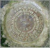
The new elevations are part of an ongoing effort in Louisiana to improve the accuracy of survey benchmarks and make sure that they remain accurate over time. I've posted previously on NOAA's study of subsidence along the coast. Basically, if the ground is sinking, the benchmarks are sinking with it, and such lowering can go unnoticed. To keep elevations accurate, Congress has funded height modernization programs for four Gulf Coast states. As part of this height modernization effort the National Geodetic Survey is analyzing the historical leveling data as well as new leveling and GPS surveys. They are feeding the data into updated scientific models to provide more accurate elevations on benchmarks in southern Louisiana.
posted by Roger Hart @ 10/29/2005
|
![]()
![]()


<< Home