

National Geographic Plans "Mega-Map" Of Sonoran Desert Region
 The National Geographic Society plans to produce a "Geotourism MapGuide" of the Sonoran Desert Region the Arizona Daily Star reported today. In a new twist, the MapGuide, which will cover more than 84,000 square miles of Southern Arizona, Sonora and Baja California, will highlight 200 to 300 sites nominated by the public. Each site will be remarkable for its scenery, history, culture, art or cuisine.
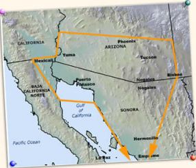
The map, to be printed in English and Spanish, is intended to promote "geo-tourism." The society defines geo-tourism as, "tourism that sustains or enhances the geographical character of the place being visited  its environment, culture aesthetics, heritage and the well-being of its residents." The area to be mapped reaches west to Mexicali in Baja California and east to the Bisbee area, though the boundaries are subject to change.
The society is accepting nominations for all kinds of places to be included on the map, from magnificent canyons to places to get handmade tortillas. To nominate a site for inclusion, visit their website here.
posted by Roger Hart @ 3/05/2006
|
![]()
![]()


<< Home