

Maps As Art: Ancient Thai Maps To Be Displayed
 Five ancient maps of Thailand, dating back as far as 1782 will go on display this month at the Jim Thompson Art Center in an exhibition entitled "Siam in Trade and War - Royal Maps of the Nineteenth Century". Thai Day reports that the maps are part of a a group of 17 maps discovered at the Grand Palace back in 1996.
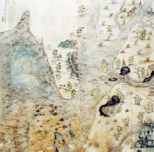
Hand drawn and colored on cotton, the maps cover Siam, Burma, Cambodia and China. The maps are reportedly rich in detail depicting a country studded with temples, trees and forts. The lakes and rivers are shown filled with fish and Chinese junks.
Not only are the maps beutiful, but they are historically important as well. "These maps represent primary sources of information for the study of Siamese and Southeast Asian history and geography for years to come," Santanee Phasuk, one of the exhibition's co-curators told Thai Day.
The maps are a unique find in Thailand as only one other topographical map from the era is known to exist. Narisa Chakrabongse, another co-curator explained why. "Maps at that time were trade secrets, and only big companies such as the Dutch India company would have them." However European maps of the area concentrated on shipping routes, with sparse information on the interior. Researchers have confirmed that topographic maps' are highly accurate for their time.
Thai Day explains how the maps were dated:
To pinpoint when the maps were drafted, the researchers used orthography (the examination of written letters in ancient manuscripts), looking at their tone marks, the handwriting and the spelling. They found that the style of the maps differed from Thai nineteenth-century painting, with its rich and varied coloring. Other characteristics are animals in natural environments and elaborate architecture.Exhibition of the maps runs from January 28 to March 31.
posted by Roger Hart @ 1/23/2006
|
![]()
![]()


<< Home