

Firm Completes 3-D Map Of California
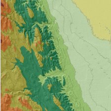 Denver-based Intermap Technologies Corporation announced today that it has completed a new digital three-dimensional map of the state of California. The firm says that the map is the most accurate three-dimensional color map ever produced of the state.
Intermap intends the map for applications such as: geographical information systems (GIS), engineering planning, transportation, automotive, navigation, flood, irrigation, environmental management and planning, telecommunications network planning, aviation, simulation and 3D visualization.
The firm plans to complete maps of Texas, Oklahoma, Arizona, New Mexico, as well as complete a map of Germany by the end of the year. The firm eventually plans to map the entire United States.
posted by Roger Hart @ 1/19/2006
|
![]()
![]()


<< Home