

NOAA Announces Major Contracts For Hydrographic Mapping
 Five different firms have been awarded contracts to provide hydrographic mapping services to the National Oceanic and Atmospheric Administration (NOAA). The contracts could be worth up to $50 million each, though the actual amount is dependent on congress providing funding. The firms selected for their qualifications are C&C Technologies Inc., SAIC, David Evans and Associates, TerraSond Ltd., and Fugro Pelagos.
NOAA will engage the firm's services for specific projects on an as-needed basis over the next five years. However, one firm has already been engaged for two projects in the Gulf of Mexico. C&C Technologies, Inc. will begin mapping the approaches to Port Fourchon, Louisiana and surveying in the Gulf to support U.S. interests defined in the United Nations Convention on the Law of the Sea. The busy 2005 hurricane season left debris and possibly other obstructions to navigation in the Gulf.
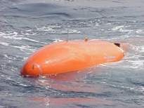
Separately, C&C Technologies was awarded two $3.75 million contracts. The first contract supported a recently completed mapping of the seafloor in the Gulf of Mexico and the Straits of Florida. Under the second contract, C&C Technologies will develop a semi-submersible unmanned vehicle. The goal is to apply new technology about the engineering and operation of unmanned vehicles in ocean exploration and mapping. The vehicle will also serve as a test-bed platform for development and evaluation of new instruments and sensors.
See also:
New Craft To Help Survey The Ocean Floor
posted by Roger Hart @ 2/24/2006
|
![]()
![]()


<< Home