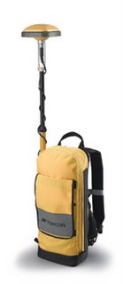
New Topcon Unit Integrates GIS & Land Surveying
 Topcon Positioning Systems, yesterday introduced GMS-110, which integrates GIS data collection and land survey systems. Mike Weir, worldwide GIS sales manager for Topcon says the GMS-110 will operate with software solutions based on ESRI's ArcPad, making it, "perfect for the advanced GIS professional." The unit is also compatible with Topcon's TopSURV-GIS, featuring both GIS data collection and land surveying functions. The unit is designed to work with Topcon's FC-100 field computer. Other data controllers can also be used with the system.
Topcon Positioning Systems develops and manufactures a wide range of positioning equipment utilizing GPS, laser, optical surveying, and machine control.


<< Home