

Leica Launches RTK Network In Britain
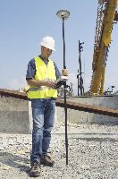 Swiss equipment manufacturer Leica Geosystems announced yesterday that it had launched Great Britain's first commercial Real Time Kinetic (RTK) Global Positioning System (GPS) network. The service, which the firm calls, "Leica SmartNet" is available as a broadcast correction service to subscribers via GSM or GPRS technology in Great Britain. The service is a partnership between Leica Geosystems and Ordnance Survey.
By using the network, users needing high precision GPS locations will no longer have to use multiple GPS receivers. A spokesperson for Leica said that users, can work at full precision, in Ordinance Survey Grid, anywhere in the country. The system is based on raw data from the Ordnance Survey's network of 90 GPS base stations.
The network is available to anyone, no matter what brand of GPS equipment is used, via an annual subscription.
posted by Roger Hart @ 2/08/2006
|
![]()
![]()


<< Home