

Old Maps Of New England Available On CD
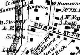 The Burlington Free Press reports on the efforts of David Allen to use modern technology to allow everyone the chance to enjoy and use historic maps. Mr. Allen has recently made available on CD-ROM, maps of Vermont from the the 1850s. These maps were scanned from the original hand colored originals, and feature detailed illustrations of the road systems, homes and businesses of the period and even include many of the homeowners' names.
Mr. Allen has been documenting 19th century New England, through old maps since the 1980s. The Vermont maps are his latest project. It took approximately 500 separate scans to cover the state. The maps were found in the hands of antique dealers, the Library of Congress and the Vermont Historical Society.
Historians, genealogist, interested in New England, or anyone that appreciates the skill of old mapmakers should visit his website.
posted by Roger Hart @ 1/06/2006
|
![]()
![]()


<< Home