

Researchers Conduct Most Detailed Survey Ever of San Andreas Fault
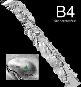 A team led by Ohio State University (OSU)has finished the most detailed survey ever made of the San Andreas Fault, revealing features that have never been seen before. Combining Lidar, which stands for"light detection and ranging," with Global Positioning Systems (GPS) technology, the researchers were able to map the surface of the San Andreas Fault with 5-centimeter (1.97 inches) vertical resolution.
Michael Bevis, a professor of geodynamics at OSU, displayed the first images from the survey Wednesday at the American Geophysical Union meeting in San Francisco. A more formal presentation is scheduled for Wednesday, Dec. 7, at the same conference. The team will spend the next year processing the remainder of the survey data, making it available to scientists on the web.
The survey project was called the "B4" Project, because the data will form the "before" images that scientists will compare to "after" images of the next big San Andreas earthquake when it inevitably happens. Scientists hope that by comparing the "before" and "after" images, that they can gain a better understanding of what happens near or in the fault, as well as how an earthquake starts.
The research team included members from several universities as well as the United States Geological Survey. The project was financed by the National Science Foundation and NASA.
posted by Roger Hart @ 12/06/2005
|
![]()
![]()


<< Home