

Remembering The Past: Marking The Mason-Dixon Line
 On a map, 39 degrees 43 minutes north latitude appears to effortlessly traverse across North America. But a story in today's Charleston Gazette-Mail reminds us that in the 1760's two men undertook the near Herculean task of marking the invisible line. The purpose of the survey was to settle a land dispute between two wealthy colonial clans, the Penns of Pennsylvania, who held title to a huge land grant on the north side, and the Calverts of Maryland who had holdings nearly as vast to the south. The job of marking that line, which today separates the states of Pennsylvania and Maryland, had been assigned to British astronomer Charles Mason and surveyor Jeremiah Dixon.
A Monumental Task
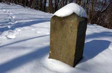
It was thought that the survey would take one or two years to complete. It ended up taking more than four. In the summer months, the team working on marking the line might number as many as 115. Not only did they have to haul all of the astronomical instruments and supplies, but they also had to haul 500-pound stone monuments that had been quarried in England to mark each mile of the survey. Even larger "crownstones" bearing the coats of arms of the Penns and the Calverts, were set every five miles. Besides the monuments, they also placed stones at the crests of hills where the line crossed them. Finally, as the terrain became too rugged to carry the huge monuments, they began monumenting the line by piling up stones by hand.
Commendable Accuracy
About Messrs. Mason and Dixon's work, Todd Babcock, a member of the Mason and Dixon Line Preservation Partnership, told the Gazette, "Considering the equipment that was available to them and the conditions they were working under, it's amazing how accurate they were. Near Emmitsburg, Maryland, the stones are about 900 feet south of the intended latitude, and at Browns Hill, they were about 500 feet south." However, modern-day surveyors using Global Positioning System technology have determined that for much of the route, the surveyors were within a few feet of the true line.
Unfinished Business
Messrs. Mason and Dixon were not able to finish their work. On October 10, 1767, just north of modern-day Core, West Virginia, their survey came to an end. Their Native American guides refused to go any further, fearing that they would anger other tribes, whose land they did not have permission to cross. The team set a final post, marked, "W" on the west side and returned home. In total, they had surveyed 233 miles, 17 chains and 48 links.
More Than A Survey
The Mason-Dixon line became much more than a resolution to a property dispute. Prior to the Civil War, the line marked the division between those states that allowed slavery and those that did not. In later years, the line came to symbolize a cultural difference between northern states and southern states. Differences that continue to this day.
posted by Roger Hart @ 12/18/2005
|
![]()
![]()


<< Home