

World's Oldest Map Discovered In Italy
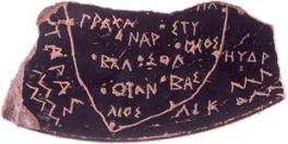 Archaeologists digging in southern Italy have discovered what they say is the oldest map of anywhere in the western world. The London Telegraph reports that the map, known as the Soleto Map, depicts Apulia, recognizable as the heel of Italy's "boot". It is depicted on a piece of black-glazed terracotta vase about the size of a postage stamp and dates to approximately 500 BC.
The map was unearthed by the Belgian archaeologist Thierry van Compernolle, two years ago. The discovery was kept secret until more research had been done. It was put on display this week in the Archaeological National Museum of Taranto.
Besides being the oldest map from classical antiquity ever discovered, the map is the first proof that the ancient Greeks were drawing maps before the Romans. Modern mapmaking traces its roots to methods developed by the ancient Greeks.
More from the Telegraph:
The Soleto map is a contemporary of the Greek mathematician Pythagoras, who set up a philosophy school in Crotone, now Calabria, on the other side of the Gulf of Taranto.
His hypothesis that the Earth was round, developed after observing that the height of stars was different at different locations and noticing how ships appeared on the horizon, formed the basis of modern map making.
posted by Roger Hart @ 11/17/2005
|
![]()
![]()


<< Home