GeoCarta Has Moved

Mar 10, 2006

Impressive Collection Of Historic Maps

While posting the story about the firm combining historic and new maps through Geographic Information Systems technology, I came across an great new online resource of historic maps.

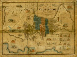
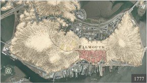
The Osher Map Library at the University of Southern Maine houses the map collections of Lawrence M. C. and Eleanor Houston Smith, Dr. Harold L. and Peggy L. Osher, and Dr. Peter M. Enggass as well as many other individual maps.

The Osher Map Library is located on the ground floor of the Albert Brenner Glickman Family Library on the Portland campus of the University of Southern Maine. If, like me, Maine is a long way from home but you still appreciate historic maps, the library has a number of its current and past exhibitions posted on its impressive website. I've bookmarked the site for more browsing.

See also:
Old Maps Of New England Available On CD


Labels:

Small Firm Combines GIS With Historic Maps

Two students from the University of Southern Maine (USM) have recently gone full-time with their firm which specializes in combining Geographic Informations Systems (GIS) technology with historic maps and other records. Maine Today has a story about Rosemary Mosher and Kirsten Read Boettcher, co-founders of Orbis, LLC.

Orbis specializes in "land use investigations and historical forensics." The firm uses GIS to create layered maps that show historic geographies and ways property was used in the past.

From Maine Today:

They make innovative uses of mapping software and combine it with painstaking and extensive historical document searches to create rich and graphic portrayals of areas. The end result can tell a real estate developer, for instance, what the history of a parcel is, whether he might encounter graves from a century-gone churchyard or ground contaminated with arsenic from a tannery that was there 80 years ago.


That sort of graphic interpretation is valuable to many different types of businesses, said Meriby Sweet, director of the Maine Small Business and Technology Development Center at the Maine Technology Institute. Sweet has advised Orbis on the company's business model.

"It provides the linkage between the sort of dry, flat map that says, 'Here's where we sit on the surface of the earth, this is where the boundaries are, where the lakes and rivers and oceans are,' and it adds the dimension - 'look, there's this whole long history of people actually inhabiting this not-so-flat surface,' " said Sweet.

The two principals met at USM. A professor suggested they work on a project together - one that combined GIS with history. When the project ended, they worked various freelance jobs together, combining historic and modern maps using GIS. In 2004, they founded Orbis.

The firm seems to have a found a niche in the environmental field. Ms. Mosher told Maine Today she thinks Orbis can help developers recognize potential issues before they become problems through a better understanding of historical land uses.


Labels: ,

New Version Of NOAA's NowCOAST Web Mapping Portal Features Real-Time Data

The National Oceanic and Atmospheric Administration (NOAA) has launched an updated version its nowCOAST web portal. NowCOAST uses Geographic Information System (GIS) technology that allows users to overlay other datasets and NOAA forecast products with these on-map displays to get a detailed picture of present conditions. The improved web mapping portal now features coastal observations and NOAA forecasts in real-time. This latest version also allows users to view the latest Geostationary Operational Environmental Satellite cloud imagery, and NOAA National Weather Service weather radar images.

The new mapping portal also includes geo-referenced hyperlinks to observations from river and water quality observing networks, coastal Web cams, as well as NOAA marine and weather forecasts and forecast guidance from NOAA weather, ocean, estuarine, and river computer prediction models. NowCOAST includes an interface to accommodate both novice and experienced GIS users to allow both to quickly view real-time environmental conditions for any U.S. coastal area.

See also:
Gulf Coast Navigation Charts Posted Online


Labels:

Mar 9, 2006

Map Wins British Cartographic Society Award

A map of the Royal Borough of Kensington and Chelsea has been named joint-winner of the British Cartographic Society's Ordnance Survey MasterMap 'Better Mapping' award eGov Monitor reported today. The map was commissioned by Kensington and Chelsea Council for its interactive travel information website.

The "map" is actually more of a website that allows the users to make their own maps, choosing from a wide range of features to be depicted. The map was created for the Council by Oxford Cartographers Ltd. It was based on Ordnance Survey MasterMap and Ordnance Survey OSCAR road network. The judges praised the map for its clarity and user-friendliness as well as being "aesthetically pleasing."

You can take a look at the winning map here.

Labels:

Yet More Indian Concerns Over Google Earth

It appears India is still upset with Google Earth.

From the Times of India:
The Government told the Rajya Sabha that efforts were being made to mask certain areas of high resolution imagery from the Google Earth website that has caused security concerns in the country.

Replying to supplementaries during Question Hour, Minister of State in the Prime Minister's Office Prithviraj Chavan said the Ministry of Science and Technology and the Defence Ministry were in touch with concerned agencies to see if certain areas can be masked from the website.

In this regard, work was going on between the concerned Ministries to make it low resolution imagery in certain areas of the website, the Minister said.
The Rajya Sabha or "House of States" is the upper house of the parliament of India, similar to the U.S. Senate. The whole thing shows the futility of trying to regulate information in the digital age. Governments move so slowing that by the time they get around to passing any laws, it has basically become a moot point..

See also:
India Forms Group To Address Google Earth Concerns
Google Earth: Complaints and Restrictions
India Protests Google Earth
More Complaints Over Google Maps


Labels:

Mar 8, 2006

Chicago Realtors, Cartographer, Head Back To Court Tomorrow

From Crain's Chicago Business:
A business partnership between the maker of a popular Chicago neighborhood map and the Chicago Assn. of Realtors has gone sour.

The parties are due in court Thursday in the latest installment of a lengthy case in which the cartographer has accused the association of a hostile takeover attempt and the association has alleged the map'’s new motto is offensive, even racist.

Complete article here.


British Newspaper Bashes Ordinance Survey

Charles Arthur and Michael Cross, writers for the British newspaper The Guardian take Ordinance Survey (OS) to task. They say the mapping agency, "stifles innovation, enterprise and the creativity that should be the lifeblood of new business."

The author's argue:
Imagine you had bought this newspaper for a friend. Imagine you asked them to tell you what's in the TV listings - and they demanded cash before they would tell you. Outrageous? Certainly. Yet that is what a number of government agencies are doing with the data that we, as taxpayers, pay to have collected on our behalf. You have to pay to get a useful version of that data. Think of Ordnance Survey's (OS) mapping data: useful to any business that wanted to provide a service in the UK, yet out of reach of startup companies without deep pockets.

This situation prevails across a number of government agencies. Its effects are all bad. It stifles innovation, enterprise and the creativity that should be the lifeblood of new business. And that is why Guardian Technology today launches a campaign - Free Our Data. The aim is simple: to persuade the government to abandon copyright on essential national data, making it freely available to anyone, while keeping the crucial task of collecting that data in the hands of taxpayer-funded agencies.

One government makes the data it collects available free to all: the United States. It is no accident that it is also the country that has seen the rise of multiple mapping services (such as Google Maps, Microsoft's MapPoint and Yahoo Maps) and other services - "mashups" - that mesh government-generated data with information created by the companies. The US takes the attitude that data collected using taxpayers' money should be provided to taxpayers free. And a detailed study shows that the UK's closed attitude to its data means we lose out on commercial opportunities, and even hold back scientific research in fields such as climate change.

The writers also mention a study by Peter Weiss, of the US National Weather Service. His paper, Borders in Cyberspace: Conflicting Public Sector Information Policies and their Economic Impact, compared open and closed economic models for public sector data. The late Mr. Weiss concluded that governments take in more tax money in the long run by giving away their data, saying, "Governments realise two kinds of financial gain when they drop charges: higher indirect tax revenue from higher sales of the products that incorporate the ... information; and higher income tax revenue and lower social welfare payments from net gains in employment."

It seems the English and American publics view the role of government somewhat differently. However, not all governments in the U.S. are as accommodating as the writers seem to think. See this post.

Complete Guardian article here.

See also:
Leica Launches RTK Network In Britain


Labels:

Garmin Announces Improved Maps For Eastern Europe

Garmin International Inc., a unit of Kansas City-based, Garmin Ltd. announced today that it now features expanded map coverage for Eastern Europe. The enhanced coverage includes detailed maps of portions of Estonia, Latvia, Lithuania, Poland, Czech Republic, Slovakia, Hungary, Slovenia, and Croatia. The map data is provided by digital mapmaker NAVTEQ.

The enhanced map coverage will be available this month on either a pre-programmed accessory card, or already loaded in selected StreetPilot and nüvi personal global positioning system (GPS) navigation devices. Garmin is the leading seller of GPS navigation devices in the U.S. but holds a considerably smaller share of the European market.

See also:
Garmin Prepares To Ramp Up GPS Production
MapBiz: Garmin Reports Record Revenue
TomTom Takes #2 Spot In Booming GPS Navigation Market


Labels: ,

Autodesk Announces MapGuide Open Source Through The Open Source Geospatial Foundation

Software publisher Autodesk, Inc. announced today a new version of MapGuide Open Source. Originally called MapServer Enterprise, Autodesk has made it available on the new MapGuide Open Source site hosted by the Open Source Geospatial Foundation (OSGeo).

MapGuide Open Source is free software licensed under the GNU Lesser General Public License. It allows users to quickly develop and distribute spatial and design data over the web. Autodesk plans to offer a commercial version, called Autodesk MapGuide Enterprise 2007 later this year.

The Open Source Geospatial Foundation's mission is to support and promote the collaborative development of open geospatial technologies and data. The foundation provides financial, organizational and legal support to the broader open source geospatial community. It also serves as an independent legal entity to which community members can contribute code, funding and other resources, secure in the knowledge that their contributions will be maintained for public benefit. OSGeo also serves as an outreach and advocacy organization for the open source geospatial community, and provides a common forum and shared infrastructure for improving cross-project collaboration.

Labels:

Coming & Going: Steele Named To New Post At Tele Atlas

Digital mapmaker Tele Atlas announced today that it had appointed Mark Steele to the position of Chief Operating Officer, Asia, Middle East and Africa. In the newly created position, Mr. Steele will be responsible for all corporate, finance and business development operations in the region.

Previously, Mr. Steele was the President of ITT China, where he oversaw all corporate functions within the country. He is a member of the Board of Governors and the past Chairman of the Corporate Social Responsibility Committee of the American Chamber of Commerce in Shanghai.

Labels:

Mar 7, 2006

TomTom To Add Back Road Maps

Global Positioning System (GPS) navigation unit maker TomTom announced today that it was teaming up with MADMaps, Inc. to make the firm's scenic back road maps available on the TomTom GO and TomTom RIDER models. MadMaps' cartographers specialize in charting scenic trips along the back roads of the U.S. The firm's maps feature full-color landscape relief imaging of local elevations, mileage markers, fuel stops, recommended road side eateries, lodging and other local attractions.

Nearly all portable GPS navigation units share the same underlying maps. The TomTom GO unit gets its source map data from Tele Atlas, while Navteq provides the map data for the TomTom RIDER. So TomTom's strategy is to try to distinguish itself in a crowded marketplace with additional content not available from other brands.

See also:
For The Road Warrior With A Sweet Tooth
TomTom Takes #2 Spot In Booming GPS Navigation Market
Garmin Sues TomTom Maker Over Patents


Labels: ,

Stronger Solar Storms Predicted; May Disrupt GPS & Other Satellite Technology

The next solar storm cycle should be significantly stronger than the current one, which may mean problems for power grids and GPS systems and other satellite-enabled technology, scientists announced today. In a report in the National Geographic News, scientists say that the next 11-year cycle of solar storms could start as early as this year or as late as 2008 and should peak around 2012.

Mausumi Dikpati, a solar scientist with the National Center for Atmospheric Research predicted that the next solar cycle will be 30 to 50 percent stronger than the last cycle. The last solar storm cycle peaked in 2001. Scientists say a new technique, called helioseismology allows them to make better predictions about the severity of the next cycle. The technique allows researchers to "see" inside the sun by tracing sound waves reverberating inside the sun.

Predicting space weather is more that casual research. Solar storms can disrupt satellite communications, cause power outages, and expose astronauts to high amounts of radiation. Richard Behnke, director of upper atmosphere research with the National Science Foundation in Arlington, Virginia was quoted by the news as saying, "This prediction of an active solar cycle suggests we are potentially looking at more communication and navigation disruptions, more satellite failures, possible disruption of electric grids and blackouts, more dangerous conditions for astronauts - —all these things."

David Hathaway, a solar astronomer with NASA's Marshall Space Flight Center in Huntsville, Alabama, agrees that the next solar cycle will be stronger than the last one. However, he disagrees on when it will begin. He says that models used by him and his colleagues suggest that the next cycle will start by the end of this year or early next year.


Labels:

MapQuest Introduces Beta Version Of OpenAPI For Web Developers

Web-based map provider MapQuest announced today the initial release of free mapping and routing technology for Web developers. MapQuest OpenAPI will provide a core set of mapping, geocoding and routing tools for non-commercial use. Web developers can use OpenAPI's routing capabilities to create mashups that not display locations on a customized MapQuest map and include driving directions.

To publicize the launch of OpenAPI, MapQuest announced a contest where web developers can compete to build the most creative mashup that leverages the mapping and routing functionality of OpenAPI. The contest starts March 7 and runs through the end of March. The winner gets a $1,000 cash prize, and a trip to the Where 2.0 Conference in San Jose, California, June 13-14. Official rules are here.

One of the first web-based mapping services, MapQuest continues to rank as the top mapping site on the Web. The company says a study by comScore Media Metrix showed the site had 42 million users in January, 2006. MapQuest is a wholly owned subsidiary of America Online, Inc.


Intermap & Tele Atlas To Join Forces For Vehicle Navigation

Intermap Technologies Corporation announced today that it is teaming up with Tele Atlas North America, Inc. to develop two- and three-dimensional digital road maps. The maps will be made for the for the vehicle navigation market. Intermap says there is growing demand for highly accurate maps for use in intelligent transportation systems.

The companies plan a pilot project for California where Intermap has already completed a 3-D map. The plan will combine Intermap's 3-D maps with road vectors from Tele Atlas to allow visualization systems to operate at higher levels of detail and accuracy.

See also:
Firm Completes 3-D Map Of California
MapBiz: Intermap Signs Deal With German Automaker; Firm To Speed Up Mapping Of Europe
MapBiz: Tele Atlas Reports Record Revenue; Net Loss

Mar 6, 2006

MapBiz: Los Angeles County Extends License With Pictometry

The Los Angeles Region Imagery Acquisition Consortium (LAR-IAC) has extended its license agreement for new oblique, digital aerial imagery with Pictometry International Corp. it was announced today. Under the deal, Pictometry will provide oblique imaging capture of over 4,000 square miles of the county.

LAR-IAC provides a wide-range of digital aerial imagery and geospatial data for all county and local municipalities in Los Angeles County. As part of the deal, Pictometry's high-resolution imagery of the county will be updated and utilized by participating members via LAR-IAC. The arrangement allows the various governments in Los Angeles to share Pictometry's images and share the costs as well.

Mar 5, 2006

Updates On Previous Posts

Time for some updates, additions and corrections of old posts:

TomTom Announces New Features
The picture with this post was of an older model. The model with all the new features is pictured at right.

Flood Map Error Soaks Omaha Residents With Costs
Station WOWT reported today that about 80% of the homeowners in Omaha, Nebraska whose homes had been mistakenly been shown as being in the 100-year flood plain have had their properties removed from the flood plain.


"Phantom Roads" Provide Pitfalls For Landowners; Potential Work For Cartographers
The Barre Mountpelier Times Argus reports that the Vermont House passed a bill Friday that gives towns until July, 2012 to map out and reclaim ancient roads they want to keep. After that they lose title to the property. The bill now goes to the Vermont Senate for action.


National Geographic Plans "Mega-Map" Of Sonoran Desert Region

The National Geographic Society plans to produce a "Geotourism MapGuide" of the Sonoran Desert Region the Arizona Daily Star reported today. In a new twist, the MapGuide, which will cover more than 84,000 square miles of Southern Arizona, Sonora and Baja California, will highlight 200 to 300 sites nominated by the public. Each site will be remarkable for its scenery, history, culture, art or cuisine.

The map, to be printed in English and Spanish, is intended to promote "geo-tourism." The society defines geo-tourism as, "tourism that sustains or enhances the geographical character of the place being visited — its environment, culture aesthetics, heritage and the well-being of its residents." The area to be mapped reaches west to Mexicali in Baja California and east to the Bisbee area, though the boundaries are subject to change.

The society is accepting nominations for all kinds of places to be included on the map, from magnificent canyons to places to get handmade tortillas. To nominate a site for inclusion, visit their website here.

USGS Hydrologist, Luna B. Leopold Dies

Dr. Luna B. Leopold, an earth scientist widely considered the nation's top expert on how rivers shape the land, died February 23, in Berkeley, California the Washington Post reported today. He was 90.

Dr. Leopold was former chief hydrologist of the U.S. Geological Survey. He revolutionized the study of geomorphology by introducing quantitative methods into a discipline that had been purely descriptive. He authored approximately 200 books and articles, several of which are still used in the field. in 1991 he received the National Medal of Science. He was a member of the National Academy of Sciences and will be posthumously awarded the prestigious Benjamin Franklin Medal in Earth and Environmental Science next month.

Dr. Leopold was an avid outdoorsman. His interest in nature ranged from the study of local butterfly and sparrow populations to an intense attention to government decisions on mining, timber and water quality.

Via Fantom Planet.

Mar 4, 2006

Student GIS Club Maps Out New Nature Trail

The Dallas Morning News has a story today on the GIS Club at a suburban middle school:

The Geographic Information Systems Club and 4-H Science Club are working together to bring paved walkways and a nature observatory to a greenbelt area near the northwest corner of Frankford Road and Josey Lane in Carrollton.

The project took another step toward reality last week, as the five students who designed the trails -– Matt Zettler, Sara Pritsker, Jonathan Russell, Nathan Schiferl and Dorathy Scrudder -– and GIS club members used handheld global positioning receivers and software donated by ESRI to map the route.


The GIS club's work on the trails began last year when city of Carrollton senior engineering tech Charles Neely showcased five projects that club members could use to hone their mapping skills. Students were immediately drawn to the greenbelt.

Mr. Neely, the group's community partner, said students worked for nine months, studying city-supplied data and mapping points that would make up the trail. The Carrollton City Council voted to adopt the students' design with minimal adjustments.

Complete story from the Dallas Morning News (Registration required).

Maps As Art: Bird's Eye View Map Exhibit Open In Fort Worth

In the latter half of the 1800's cartographers made their way across the country, stopping at cities and towns along the way. They would offer the town's business leaders and citizens a deal. If enough people would agree to subscribe, an orthographic, or "bird's-eye" view map of the town would be made.

While little is known about the men who crafted these maps, their work continues to impress mapmakers and others today, and is studied by historians. The Amon Carter Museum in Fort Worth recently opened a new exhibit. "Patterns of Progress - Bird's Views of Texas" displays more than fifty bird's-eye view maps and the cities and towns of Texas.

A recent tour of the exhibit left me impressed with the skill of the cartographers in preparing these bird's-eye view maps, maps that were made long before the airplane have even been invented. The exhibit also charts the rapid changes in society at the time. Several cities were mapped years apart, giving the viewer the chance to trace the course of early development of some of the largest metropolitan areas of Texas.

The exhibit will be at the Carter Musuem until May 28. If you can't make it to Fort Worth to see it in person, you can browse the maps online here. You can also purchase reproductions of the maps here and they would make a nice addition to the office of anyone involved in mapping.

Mar 3, 2006

OSU Scientists Publish Atlas Of China

Two Oregon State University (OSU) scientists recently published a new kind of atlas of the People's Republic of China. "Visualizing China's Future Agriculture: Climate, Soil, and Suitability Maps for Improved Decision Making", contains hundreds of unique and colorful maps of the nation. The atlas was produced by David Hannaway, OSU forage crops specialist, and Chris Daly, OSU climatologist.

Medford News reports that the atlas is the first to offer an extensive collection of maps that show climate, soil characteristics and plant species suitability for an entire country. Messrs. Hannaway and Daly are both members of the OSU China Working Group, a cooperative effort between OSU and the People's Republic of China to identify mutually beneficial research and education projects and programs.

The maps were originally produced on a web-based internet map server using Geographic Information System (GIS) technologies. "We built the online mapping system to allow users to quickly identify grasses and legumes that are best adapted to the climate and soils of a particular geographic location in the People's Republic of China," Mr. Hannaway said, "After we had finished the project and put materials on the Web, there were a lot of incredibly useful and beautiful maps that we thought should be put together into a tangible book form." The new atlas reproduces hundreds of the maps from the research project.

Mr. Hannaway says, "The book offers a wonderful visual example of how powerful GIS technology applied to climate mapping can be," he said. "It helps people who aren't scientists understand what we're trying to accomplish through this research."

Coming & Going: Telecom CEO Joins NAVTEQ Board

Andrew J. Green, CEO of BT Global Services has been elected to the Board of Directors of NAVTEQ, replacing Wilhelmus Groenhuysen. Mr. Green has been CEO of BT Global Services since 2001. He joined BT in 1986 and has held numerous different positions with the firm. Before joining BT, Mr. Green previously worked at Shell and Deloitte, Haskins and Sells.

NAVTEQ provides digital maps for auto and personal navigation systems, and for internet-based mapping applications, including some of the most populat search engine mapping services. Based in Chicago, the firm has approximately 1,900 employees in 23 countries.

See also:
MapBiz: NAVTEQ Announces Record 4th Quarter
Where Online Maps Meet The Road


Mapping Missouri Opens Tomorrow In Hannibal

"Mapping Missouri," an exhibit featuring more than 100 maps from the Missouri State Archives' collection opens tomorrow in Hannibal Missouri. The maps will be on display at The Mark Twain Boyhood Home and Museum and the Hannibal Free Public Library. The exhibit will be shared by the two groups with different sections set up at each location.

This exhibit features maps from the Archives' collection, some of which have never been shown before. The maps on display range from a land survey maps made by Antoine Soulard in St. Louis from 1796-1806, to the computer generated Lewis and Clark maps created by Jim Harlan and the University of Missouri's Geographic Resources Center in 2002. The exhibit explores the history of cartography in Missouri and the role maps have played in our everyday lives.

Admission to the map exhibit is included in the museum's general admission price. The exhibition runs till April 23.


Mar 2, 2006

GPS At Your Fingertips

Global Positioning System (GPS) equipment maker Trimble Navigation announced today that it had developed the Copernicus GPS receiver, a surface-mount, low power GPS module the size of a thumb-nail. The firm developed the receiver for use in Bluetooth devices, sport accessories, personal navigators or cameras, computer and communication peripherals. Trimble says the module could also be used in vehicle tracking, navigation, and security products.

The firm says the Copernicus GPS receiver can acquire satellite signals and generate position fixes with high accuracy in difficult environments and under poor signal conditions. The receiver is expected to be available in the third quarter of this year.

If you're wondering why the big push for smaller and smaller GPS devices, well Reuters explains that part of the demand is being driven the government. A current article details how U.S. law requires all mobile phones to have an electronic signal, giving the owner's location. To comply, U.S. mobile phone operators now sell mobile phones that contain a GPS chip.

The article goes on to explain how the law has opened up a new market for web services firms like Google, Yahoo, and Microsoft.

See also:
GPS Use To Take Off: Majority Of Cellphones GPS Enabled By 2011
MapBiz: GPS Boom Yields Record Earnings For Trimble
Cell Phone Maker Takes Stake In GPS Firm
GPS Receiver The Size Of Baby's Fingernail Developed

Firms Team Up To Develop 3-D Map Of Germany

Denver-based Intermap Technologies Corp. is joining forces with GeoContent GmbHX of Magdeburg, Germany to develop a 3-dimensional color digital map of Germany it was announced today.

Intermap plans to have all of Germany mapped by the end of 2006. As elevation data becomes available for different parts of the country the two companies will merge their datasets. GeoContent is the only German firm with a countrywide digital aerial image. The existing GeoContent imagery will be geo-referenced and "draped" over Intermap's digital terrain model. The two firms say the effort will result in the most accurate 3D map of Germany in existence.

The companies will jointly market the new map. Intermap has recently signed deals with German automobile makers to provide country-wide digital maps for use in their navigation and other systems. However, the two firms say they have their sights set on other industries as well. "A countrywide 3D image dataset combined with additional geo-referenced data presents numerous and compelling applications for not only the traditional geospatial data users, but also for a wide variety of other markets," said Dr. Manfred Krischke, managing director of Intermap Technologies GmbH.

See also:
MapBiz: Intermap Signs Deal With German Automaker; Firm To Speed Up Mapping Of Europe
Firm Completes 3-D Map Of California


MapBiz: Tele Atlas Reports Record Revenue; Net Loss

Netherlands-based digital map maker, Tele Atlas today reported record gross revenue for the fourth quarter and all of 2005. The company, which provides the digital maps and other content for the internet and navigation systems said revenue for 2005 was up 57% to 200.1 million euros (about 238.7 million U.S. dollars). The company's 4th quarter revenues were up 36% to 57.8 million euros (about 69.0 million U.S. dollars).

The company touted its full year adjusted EBITDA (earnings before interest, taxes, depreciation, and amortization) of 14.7 million euros (about 17.5 million U.S. dollars) which compares favorably to a loss in 2004 of 22.5 million euros (about 26.8 million U.S. dollars. However, if you look past the accounting gimmicks, Tele Atlas's net loss for 2005 actually increased to 21.6 million euros (about 25.8 million U.S. dollars) from 5.8 million euros (about 6.9 million U.S. dollars).

Not surprisingly, the company urged investors to look at the Adjusted EBITDA numbers. In a press release, Tele Atlas said, "The Company believes that Adjusted EBITDA provides the best measurement of operating performance, as it eliminates the impact of the large variations in non-cash expense items that the Company has experienced since 2004." However, investors didn't seem to be buying that argument as the company's stock fell 1.48 euros (6.1%) in trading on the Frankfurt Stock Exchange.

Tele Atlas employs 2,300 full-time staff and contract cartographers in 20 countries to update its maps.

TomTom Announces New Features

Consumer Global Positioning System (GPS) navigation maker TomTom, announced yesterday new features its GO series of navigation units deigned to make them smarter and easy to use.

Among the new features on the newly design units are a high resolution, wider LCD touch screen, more precise GPS performance, hands-free calling, better map coverage, an MP3 player, and text to speech functionality for spoken text messages.

The company says it has improved weather and traffic services as well. Units with the new features are expected to be available in mid-April.

See also:
For The Road Warrior With A Sweet Tooth
TomTom Takes #2 Spot In Booming GPS Navigation Market
Garmin Sues TomTom Maker Over Patents